
Colorado Grays Peak: Complete Hiker’s Guide to the Front Range
Colorado Grays Peak
Rising above the clouds in the Front Range of the Rocky Mountains, the majestic Colorado Grays Peak. One may see the unspoilt grandeur of the American West in the Peak. This Peak is frequently the first introduction to high-altitude trekking for many hikers, marking a significant turning point in their outdoor adventure. The mountain offers an absolutely stunning vista of the surrounding wilderness from its Peak, which is more than fourteen thousand feet in elevation. Colorado Grays Peak is a popular spot for locals and visitors alike to enjoy the high country because of how easy it is to get to the trailhead and how reasonable the primary path is.
The Allure of the Continental Divide
Because its highest point is located on the Continental Divide, this area has extraordinary topography. Water that falls on one side eventually finds its way to the Atlantic Ocean, while water that falls on the other side finds its way to the Pacific. Going over these ridges really brings home how massive the continent is. The ascent is more than just a physical challenge; it’s a journey through many environmental zones, from the lush evergreen forests at the base to the delicate alpine tundra at the pinnacle. Due to the thinner air, every stride becomes a test of focus and stamina at these altitudes. An unmatched feeling of accomplishment awaits the hardworking traveller.
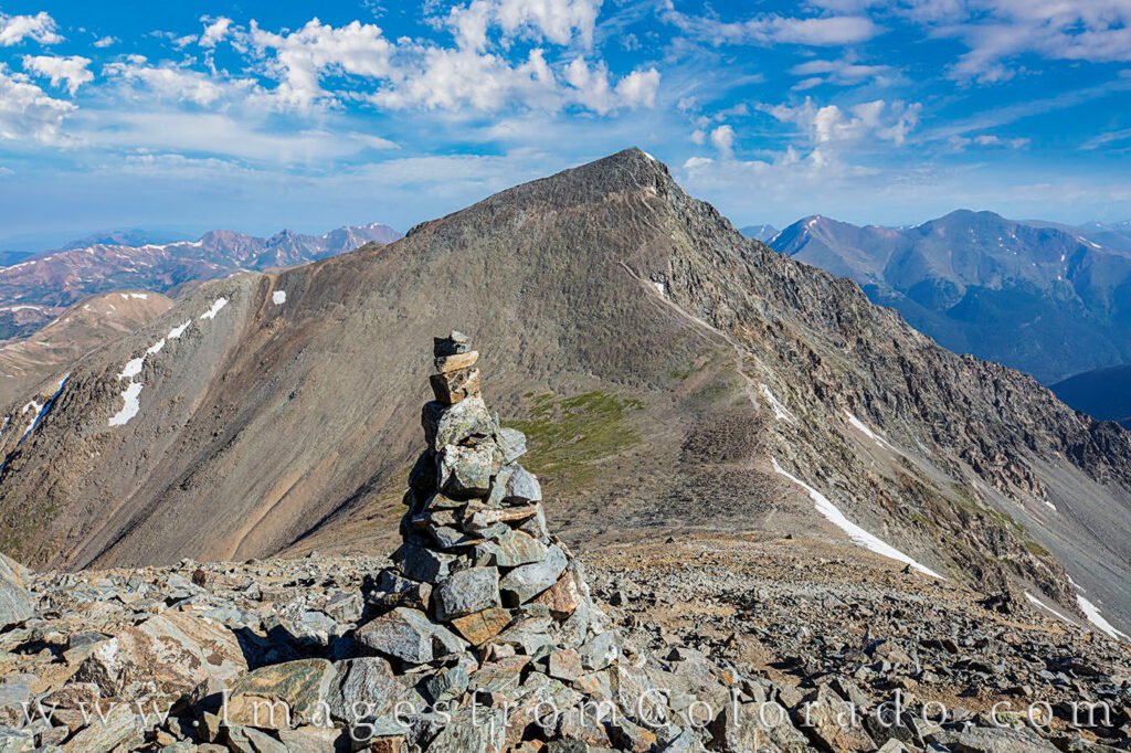
Grays and Torreys Peak: The Famous Duo
Tourists flock to this region in particular for the chance to summit not one, but two enormous peaks in a single day. A high-altitude saddle connects Greys and Torreys Peaks, allowing hikers to go from one Peak to the other with minimal additional height gain when compared to beginning from the valley floor. An iconic Colorado trail, this crossing provides a thrilling alternative to the monotony of an out-and-back trip over a magnificent ridgeline. As you stand atop the saddle, you can take in the stark outline of the nearby mountain and the magnitude of the geological forces that, millions of years ago, pushed these rocks upwards.
Conquering Torreys Peak
Although the central Peak usually gets all the attention, Torreys Peak isn’t without its own allure and difficulties. The steep northern face and the famous Kelso Ridge climb give it a somewhat more craggy appearance, despite its significantly lower elevation. The last ascent from the saddle is brief but steep, so those using the conventional route will need to use a little more lung force. At the top of Torreys, you’ll be able to take in a stunning view of the entire trail you’ve just hiked. From here, you may see the Front Range from a new angle, as you gaze north towards Longs Peak and the enormous Rockies.
Preparing for the High Altitude Environment
Safety in the mountains begins long before you reach the trailhead. The weather at fourteen thousand feet is famously unpredictable, even in the middle of summer. It is not uncommon to start a hike in seventy-degree sunshine and encounter a snow squall or a lightning storm by noon. Experienced mountaineers recommend being off the summit and heading back down into the trees by midday to avoid the risk of afternoon thunderstorms. Proper hydration and nutrition are also vital; your body burns significantly more energy at high altitudes, and the dry mountain air can lead to dehydration faster than you might realize.
Essential Gear for the Ascent
Your journey will be more enjoyable if you pack sturdy, environmentally appropriate gear. When you’re in the Rockies, layer up for maximum comfort. Each pack needs a waterproof outer shell, an insulating middle layer, and a base layer that wicks away moisture. Sturdy, high-traction shoes are required because the track’s rough rock and scree can make the descent treacherous. On the long descent, many individuals also discover that trekking poles are a godsend for their knees. To assist you in selecting the appropriate gear for this particular terrain, TheCavee.com provides in-depth evaluations of the top mountain equipment and safety necessities.
The Impact of Seasonality
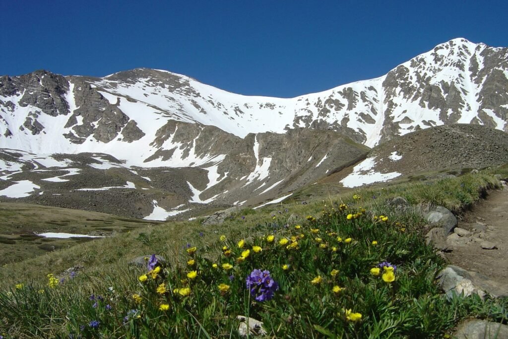
Typically, the paths are blanketed in thick snow before June, thus specific equipment such as ice axes and crampons will be required for their navigation. The road leading to the trailhead becomes impassable for the majority of cars when the first significant snowstorms reclaim the summits in late fall. If you want to see the wildflowers in bloom and the route in good condition, it’s best to visit during the summer when temperatures are high. On the other hand, this is when things really heat up, so if you want to get a parking spot, you might have to get there before sunrise.
Wildlife and Alpine Flora
As you ascend, keep a sharp eye out for the unique residents of the high country. Mountain goats are frequently spotted near the rocky summits, navigating the vertical terrain with ease. You might also hear the high-pitched whistle of a marmot or see a pika scurrying between boulders to collect grass for the winter. The plant life is equally fascinating; the alpine tundra is home to tiny, resilient flowers that grow low to the ground to survive the harsh winds. It is essential to stay on the designated trail to avoid stepping on these delicate organisms, as they take years to grow and can be destroyed in a single footstep.
Navigation and Trail Conditions
The Stevens Gulch Trail is the most popular since it is low-traffic, well-marked, and easy to find in excellent light. However, the road leading to the trailhead is notorious for its deep potholes and rough surface. A high-clearance vehicle is strongly recommended to reach the upper parking area. If you are driving a smaller car, you may need to park further down the road and add extra mileage to your day. The trail itself starts with a gradual climb through a beautiful valley before becoming a series of long switchbacks that lead up the flank of the mountain.
Achieving Peak Performance
Training for a high-altitude hike involves a mix of cardiovascular exercise and strength training. If you are coming from sea level, it is a good idea to spend a few days in Denver or a mountain town like Silver Plume to acclimate before attempting the summit. This gives your red blood cells time to adjust to the lower oxygen levels. Listening to your body is the most critical skill you can bring to the mountain. If you start to feel dizzy or develop a severe headache, it is a sign that you should descend. The mountain will always be there for another attempt on a different day.
Finding Professional Guidance at TheCavee.com
Navigating the complexities of mountain sports can be a daunting task for those just starting. This is why having a trusted source of information is so essential for the modern adventurer. At TheCavee.com, the focus is on providing high-quality, human-centered advice that covers everything from technical gear to destination guides. By visiting thecavee.com, you can learn more about how to prepare for the unique conditions of Colorado’s high peaks and ensure that your experience is as safe as it is memorable.
Respecting the Wilderness
The philosophy of Leave No Trace is essential when visiting popular spots like Colorado Grays Peak. With thousands of visitors each year, the collective impact on the environment can be significant. This means packing out all trash, including orange peels and nut shells, and respecting the silence of the wilderness. By being a responsible steward of the land, you help ensure that future generations can enjoy the same pristine views and wild experiences that draw us to the mountains today.
The Spiritual Reward of the Summit
Colorado Grays Peak is a certain clarity that comes with standing at the highest point of the horizon. The noise of everyday life fades away, replaced by the sound of the wind and the feeling of the sun on your face. It is a place for reflection and for realizing our place in the natural world. Whether you are seeking a physical challenge, a photographic opportunity, or a moment of peace, the journey up this mountain offers it all. It is a reminder that the best things in life often require effort, patience, and a willingness to keep moving upward.
Frequently Asked Questions
What is the total distance of the hike?
The standard round trip for the main trail is approximately eight miles. If you decide to include the neighbor peak, the total distance increases slightly to around nine miles with additional vertical gain.
Is this hike suitable for beginners?
It is nonetheless a very physically demanding endeavour, despite its reputation as one of Colorado’s easier fourteeners. Beginners should be in good physical condition and have at least some experience with hiking at lower elevations before attempting this summit.
Do I need a permit to climb?
As of the current season, a permit is not required for day hiking, but parking is limited and strictly enforced. Always check for the latest local regulations before you leave, as rules can change.
How much water should I carry?
Most hikers should carry at least two to three liters of water. You will be dehydrated from the dry air and physical exertion, and there won’t be many places to fill up until you leave the forest floor.
What time should I start the hike?
Starting at or before 5:00 AM is standard practice. This allows you to reach the summit and begin your descent before the common afternoon thunderstorms develop, which usually occur between noon and 2:00 PM.
Can I bring my dog?
Dogs are welcome; however, they must be leashed at all times. To protect your dog’s paws from the rugged terrain, take them on long excursions only if they’re used to it and give them water often.